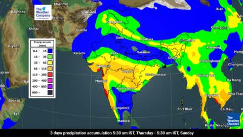
Thursday, July 20: While northern and coastal parts of Karnataka have been revelling in exceptional amounts of rain since the beginning of the month, Bengaluru and south interior areas continue holding on by a thread. However, an upcoming patch of intense rains could serve as just the remedy to this monsoonal misery.
According to the India Meteorological Department (IMD), a curious monsoon trough has gallivanted southward, switching it to an 'active state'. This movement, along with a shear zone near Gujarat, promises to drench Karnataka with copious amounts of moisture over the coming days.
Like many Bengaluru residents, you've probably felt like the recent weather is a lot more wind and not enough rain. However, this will likely change soon, with IMD predicting light to moderate showers over most parts of the southern state over the next five days.
In addition to heavy rain patches (64.5 mm-115.5 mm) sprinkled all over the state, coastal Karnataka is also likely to witness very heavy downpours (115.6 mm-204.5 mm) till Monday (July 24). Light rain and clouds will also garb Bengaluru skies till Sunday (July 23).

As a result, some weather warnings will reign over the southern state for the next few days. IMD has placed North Interior and Coastal Karnataka on an orange alert (meaning 'be prepared') on Thursday, while the rest of the region will continue under a yellow watch (meaning 'be updated') for the next five days.
Looking closer, district-level orange alerts have also been assigned to Belgaum, Udupi and Uttar Kannada districts on Thursday and Monday, and Uttar Kannada and Udupi on Friday.
Meanwhile, both N.I. Karnataka (29% excess) and Coastal Karnataka (33% excess) have outdone themselves in terms of rainfall so far this July. However, south interior parts of the state continue to wrangle a 6% rain scarcity since the beginning of the month. It remains to be seen whether this trend will continue as we enter the last week of the month.


0 Comments